Sunday, January 30, 2022

A coincidence of dates

Every few years I manage to discover something previously unknown in my genealogical meandering. Recently it was the children of Wilhelmine Elisabeth Havermann Rademacher on an Ancestry website. Note that the site incorrectly positions her among the children. Elisabeth (known as Sette) was a sister of my grandfather Friedrich (known as Fritz) Havermann (1869-1945).

Sette's children are welcome additions to my personal "Havermann" family tree. There was another piece of information on that Ancestry website: Elisabeth's death date is given as 17.05.1943, supposedly in Arnsberg. A search for that specific date yields a number of hits related to Operation Chastise, wherein the dam at the Möhne reservoir was destroyed. Many of the deaths from the resulting flood occurred in Neheim (which, since 1975, is a part of Arnsberg). Neheim is not only where I was born, but also (I believe) the hometown of my grandaunt Elisabeth Rademacher. If Sette was a casualty of that flooding, this was not something of which I had been previously aware. Mind, prior to my father's death, his aunts and uncles (and their offspring) generally were not something of which I recall being really conscious. If he had ever talked about any of them, it failed to make a sufficient impression on me (i.e., that they were his relatives).

My research associate, Marlene Frost, has Ancestry access and was able to dig up the 1928 and 1936/37 address directories for Neheim showing that Elizabeth and some of her children lived at Möhnestraße 11, not far from the Möhne river (downstream from the reservoir). The Möhne joins the Ruhr in Neheim. Sette's death informant, instead of providing particulars, had simply made a reference to the Möhnekatastrophe, hence the date.

Möhnetalsperre 17 May 1943 (Fotarchiv Ruhrverband)

Monday, January 24, 2022

How not to communicate one's GPS location

"The owner of this Apple Watch has taken a hard fall and is not responding to their watch. The emergency location is latitude 47.7, longitude -117.5, with an estimated search radius of forty-one metres."

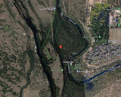
Bob B. (presumably no relation to the unfortunate Amanda A. who flipped her car in fast-rising, muddy water) was knocked unconscious mountain biking in a forest just west of Spokane WA with his watch supposedly making the 911 call. No doubt countless targets of the advertisement will ask Google Maps for the location of the coordinates:
Wow! Exactly on a bicycle-friendly road in a wooded area. But there is something amiss. To achieve such pin-point accuracy one needs precision somewhat beyond the given tenths of a degree latitude/longitude. 47.7000 N, 117.5000 W would do it, although the 41-metre search radius suggests 47.700 N, 117.500 W is probably sufficient. A GPS location is likely given in degrees/minutes/seconds (not decimal degrees) and this would have the desired accuracy. I am not acquainted with the Apple Watch emergency-call GPS specifics but I will point out that by approximating the location as 47.7 N, 117.5 W (dropping the terminal zeros), it implies an error box of ~7.5 km east-west and ~11.1 km north-south. That's a search-area of over 8300 hectares! Poor Bob.
47.7º N, 117.5º W, approximation error box (in magenta), click to enlarge

Friday, January 21, 2022

Telephone puzzler

Local calls appeared to be getting through on our home-phone landline but not long-distance calls, as evidenced by a handful of instances over the course of a month. I was certain that the problem lay in some distant Bell relay device and that the technician likely wouldn't have to come into the house. I was wrong.

Ekene, technician, connecting a new cable to a nearby Bell hub

Monday, January 17, 2022

Snow

Early this morning, coming home after the dog-walk. Twelve hours later we had ~40 cm.